接下来一段时间(可能是2年左右时间),小编将逐步整理、分享一些大地测量、海洋测绘、遥感、机器学习、科学绘图、文献管理、论文撰写方面的开源程序集,这些程序来源于github或者学术机构、开发者网站等。
暂定的程序:
- GMT
- Wafo
- Pandocs
- MB
- Latex
- Zotero
- git
- Jlab
- Citespace
- Proj
- GDAL
- GAT
- SWOTsimulater
今天分享的一个开源程序是卫星测高的海面高网格重构程序。
[1] MAXIME BALLAROTTA, EMMANUEL COSME, AURÉLIE ALBERT. ocean-data-challenges/2020a_SSH_mapping_NATL60: Material for SSH mapping data challenge[M/OL]. Zenodo, 2020[2021–04–18]. https://zenodo.org/record/4045400#.YHuagz8RVEY. DOI:10.5281/zenodo.4045400.
介绍
This repository contains codes and sample notebooks for downloading and processing the SSH mapping data challenge. The goal is to investigate how to best reconstruct sequences of Sea Surface Height (SSH) maps from partial satellite altimetry observations. This data challenge follows an Observation System Simulation Experiment framework: “Real” full SSH are from a numerical simulation with a realistic, high-resolution ocean circulation model: the reference simulation. Satellite observations are simulated by sampling the reference simulation based on realistic orbits of past, existing or future altimetry satellites. A baseline reconstruction method is provided (see below) and the practical goal of the challenge is to beat this baseline according to scores also described below and in Jupyter notebooks.
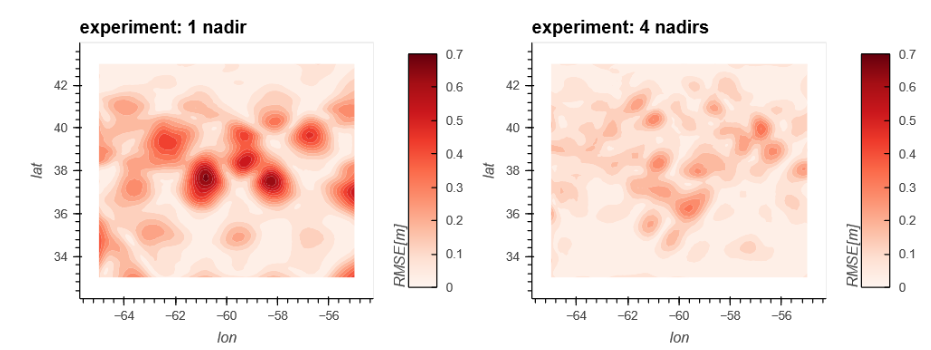
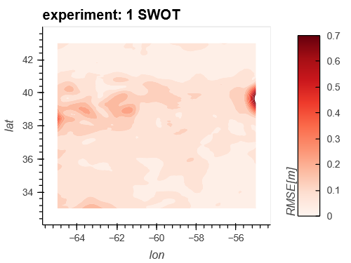
程序主要采用简单的最优插值(Optimal Interpolation)进行SSH的重构,输入数据为高分辨率海洋环流模型NATL60和真实轨道模拟的卫星高度计数据,其中模拟的卫星高度计包含Topex-Poseidon, Jason 1, Geosat Follow-On, Envisat, 和 SWOT ,重构后的高精度SSH可以促进海洋动力学等研究。
程序目录
- ocean-data-challenges-2020a_SSH_mapping_NATL60-a9b81c2
- .gitignore 39 Bytes
- LICENSE 1.1 kB
- README.md 5.9 kB
- environment.yml 610 Bytes
- figures
- DC-data_availability.png 543.9 kB
- odc-logo.png 71.2 kB
- notebooks
- .ipynb_checkpoints
- baseline_oi-checkpoint.ipynb 7.0 kB
- example_data_access_meom-checkpoint.ipynb 7.3 kB
- example_data_eval-checkpoint.ipynb 7.5 kB
- baseline_oi.ipynb 6.7 kB
- example_data_access.ipynb 12.7 kB
- example_data_access_from_cloud.ipynb 2.7 MB
- example_data_access_meom.ipynb 7.3 kB
- example_data_eval.ipynb 8.1 kB
- example_plot_results.ipynb 6.5 kB
- .ipynb_checkpoints
- quickstart.ipynb 6.2 MB
- results
- PSD_based_score.png 51.2 kB
- src
- mod_eval.py 4.4 kB
- mod_inout.py 1.5 kB
- mod_oi.py 3.2 kB
- mod_plot.py 7.3 kB
- mod_regrid.py 1.6 kB
在线测试
作者提供了快捷的在线运行,点击:https://hub.binder.pangeo.io/user/ocean-data-chal-_mapping_natl60-02h900yz/notebooks/quickstart.ipynb
该示例提供了一颗星下点高度计、四颗星下点高度计和SWOT宽刈幅高度计的SSH重构测试,并使用RMSE和功率谱给出了精度评分。
结果